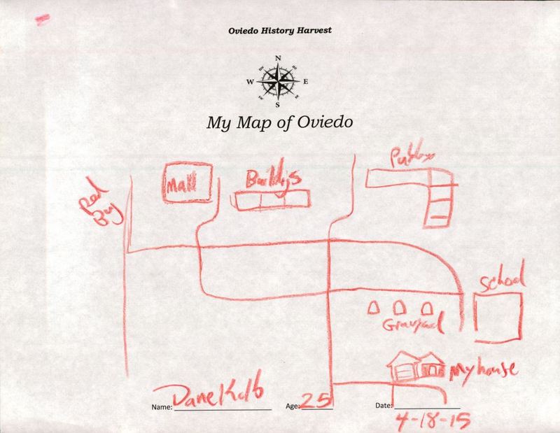
Map of Oviedo by Dane Kolb
Dublin Core
Title
Map of Oviedo by Dane Kolb
Alternative Title
Map of Oviedo
Subject
Oviedo (Fla.)
Description
A map of Oviedo drawn by Dane Kolb as part of the Oviedo History Harvest in 2015. The map shows various locations in Oviedo, including Red Bug Lake Road, the Oviedo Mall, a cemetery, a school, and Kolb's home. Kolb was 25 at the time that the map was drawn.
Creator
Kolb, Dane
Source
Original hand-drawn map by Dane Kolb, April 18, 2015: Oviedo Historical Society, Oviedo, Florida.
Date Created
2015-04-18
Contributor
Horner, Desta
Is Format Of
Digital reproduction of original hand-drawn map by Dane Kolb, April 18, 2015.
Is Part Of
Oviedo Historical Society, Oviedo, Florida.
Oviedo Historical Society Collection, Oviedo Collection, Seminole County Collection, RICHES of Central Florida.
Format
image/jpg
Extent
107 KB
Medium
1 hand-drawn map
Language
eng
Type
Still Image
Coverage
Oviedo Mall, Oviedo, Florida
Accrual Method
Donation
Mediator
History Teacher
Geography Teacher
Provenance
Originally created by Dane Kolb and owned by Desta Horner.
Donated to Oviedo Historical Society in 2015.
Rights Holder
Copyright to this resource is held by the Oviedo Historical Society and is provided here by RICHES of Central Florida for educational purposes only.
Contributing Project
Curator
Cepero, Laura
Digital Collection
Source Repository
External Reference
"RICHES Podcast Documentaries, Episode 41: Oviedo, with Dr. Richard Adicks." RICHES of Central Florida. http://riches.cah.ucf.edu/audio/Ep41-Oviedo.mp3.
Adicks, Richard, and Donna M. Neely. Oviedo, Biography of a Town. S.l: s.n.], 1979.
Robison, Jim. Around Oviedo. 2012.
"History." City of Oviedo, Florida. http://www.cityofoviedo.net/node/68.
Still Image Item Type Metadata
Original Format
1 hand-drawn map
Collection
Citation
Kolb, Dane, “Map of Oviedo by Dane Kolb,” RICHES, accessed May 11, 2024, https://richesmi.cah.ucf.edu/omeka/items/show/6339.
