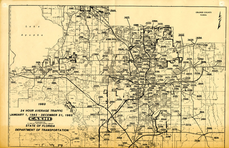
24 Hour Average Annual Traffic Map for Orange County, 1983
Dublin Core
Title
24 Hour Average Annual Traffic Map for Orange County, 1983
Alternative Title
Orange County Traffic
Subject
Orlando (Fla.)
Traffic
Description
A report showing the 24-hour average annual traffic data in Orange County, Florida, for 1983. The report was prepared by Cashi Signs, an outdoor advertising company established in 1953.
Originally a cattle town, Orlando grew into a major citrus growing center by the 1920s. The city continued to grow during the Great Depression with aid from the Work Progress Administration (WPA). During World War II, Orlando became a major military center as well, with the development of the McCoy Air Force Base and Pinecastle Air Force Base, and with the addition of the Naval Training Center (NTC) Orlando in 1968. Downtown Orlando declined in the 1960s and 1970s. Redevelopment began in the 1970s and continued into the 1980s, with projects such as the Church Street Station entertainment complex. In 1998, a building boom began and continued through the 2000s.
Originally a cattle town, Orlando grew into a major citrus growing center by the 1920s. The city continued to grow during the Great Depression with aid from the Work Progress Administration (WPA). During World War II, Orlando became a major military center as well, with the development of the McCoy Air Force Base and Pinecastle Air Force Base, and with the addition of the Naval Training Center (NTC) Orlando in 1968. Downtown Orlando declined in the 1960s and 1970s. Redevelopment began in the 1970s and continued into the 1980s, with projects such as the Church Street Station entertainment complex. In 1998, a building boom began and continued through the 2000s.
Source
Original 17 x 11 inch map by Cashi Signs, 1983: Pine Castle Historical Society, Pine Castle, Florida.
Publisher
Cashi Signs
Date Created
ca. 1983
Is Format Of
Digital reproduction of original 17 x 11 inch map by Cashi Signs, 1983.
Is Part Of
Orange County Collection, RICHES of Central Florida.
Format
image/jpg
Extent
664 KB
Medium
17 x 11 inch map
Language
eng
Type
Still Image
Coverage
Orange County, Florida
Accrual Method
Donation
Mediator
History Teacher
Provenance
Originally published by Cashi Signs.
Rights Holder
Copyright to this resource is held by the Pine Castle Historical Society and is provided here by RICHES of Central Florida for educational purposes only.
Curator
Barnes, Mark
Digital Collection
Source Repository
External Reference
Antequino, Stephanie Gaub, and Tana Mosier Porter. Lost Orlando. Charleston, S.C.: Arcadia Pub, 2012.
Rajtar, Steve. A Guide to Historic Orlando. Charleston, SC: History Press, 2006.
Collection
Citation
“24 Hour Average Annual Traffic Map for Orange County, 1983,” RICHES, accessed February 14, 2026, https://richesmi.cah.ucf.edu/omeka/items/show/7478.
