Browse Items (2 total)
- Tags: Beck Hammock
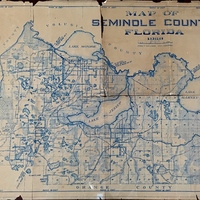
Map of Seminole County, Florida, 1928
Tags: Altamonte Springs; Astor Grant; Beck Hammock; Black Hammock; Cameron City; Chuluota; country clubs; Eureka Hammock; Florida State Road 44; Forest City; Fort Reed; Fred T. Williams; Gabriella; Geneva; Ginderville; Goldenrod; Iowa City; Kolokee; Lake Harney; Lake Howell; Lake Jessup; Lake Mary; Lake Monroe; Levy Grant; Longwood; Markham; Miranda Grant; New Upsala; Osceola; Oviedo; Palm Springs; Paola; Philip R. Yonge Grant; Sanford; Seminole County; Slavia; SR 44; St. Johns River; Wagner; Wekiva River; Wekiva Springs; Winter Park
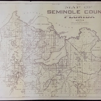
Map of Seminole County, Florida, 1954
Tags: Altamonte Springs; Astor Grant; Beck Hammock; Black Hammock; Cameron City; Chuluota; country clubs; Eureka Hammock; Florida State Road 44; Forest City; Fort Reed; Fred H. Williams; Gabriella; Geneva; Ginderville; Goldenrod; Iowa City; Kolokee; Lake Harney; Lake Howell; Lake Jessup; Lake Mary; Lake Monroe; Levy Grant; Longwood; Markham; Miranda Grant; New Upsala; Osceola; Oviedo; Palm Springs; Paola; Philip R. Yonge Grant; Sanford; Seminole County; Slavia; SR 44; St. Johns River; Wagner; Wekiva River; Wekiva Springs; Winter Park

