Sanford Municipal Airport, Sanford, Florida: Showing Proposed Drainage
Dublin Core
Title
Sanford Municipal Airport, Sanford, Florida: Showing Proposed Drainage
Alternative Title
Sanford Municipal Airport Drainage
Subject
Sanford (Fla.)
Airports--Florida
Maps--Illustrations
Drainage--Florida
Description
Proposed drainage plans proposed by Sanford's City Engineer, Fred T. Williams, for the Sanford Municipal Airport. This map was drawn on December 4, 1933. The municipal fields were selected for the site for a naval aviation training facility during World War II.
The Naval Air Station (NAS) Sanford was commissioned on November 3, 1942, as a naval aviation training facility during World War II. The Navy continued to train pilots at NAS Sanford throughout the Korean War and Vietnam War. NAS Sanford was temporarily decommissioned after World War II in 1946, and decommissioned again in 1950 when it was the Naval Auxiliary Air Station (NAAS) Sanford, due to the outbreak of the Korean War and the ongoing Cold War. Soon afterward, the station was renamed NAS Sanford and redesigned as a full naval air station. On February 6, 1959, NAS Sanford was dedicated as Ramey Field in honor of Lieutenant Commander Robert W. Ramey. In 1968, due to lack of funding caused by the Vietnam War, Congress directed the closure of NAS Sanford.
The City of Sanford assumed authority over the former NAS Sanford facility the year after it closed and renamed it the Sanford Airport, which was managed by Commander J. S. "Red" Cleveland. The airport underwent various name changes over the next several decades: Sanford Regional Airport, Central Florida Regional Airport, Orlando Sanford Regional Airport, and its current name, Orlando-Sanford International Airport. Throughout the 1980s and 1990s, several Naval buildings were demolished and new buildings were constructed.
Source
Original 17.25 x 13.25 inch drawing, December 4, 1933: "Sanford Municipal Airport, Sanford, Florida: Showing Proposed Drainage." Sanford, Florida: Sanford Museum, Sanford, Florida.
Date Created
1933-12-04
Is Format Of
Digital reproduction of original 17.25 x 13.25 inch drawing, December 4, 1933: "Sanford Municipal Airport, Sanford, Florida: Showing Proposed Drainage." Sanford, Florida
Is Part Of
Sanford Museum, Sanford, Florida.
Naval Air Station Sanford Collection, Sanford Collection, Seminole County Collection, RICHES of Central Florida.
Format
image/jpg
Extent
140 KB
Medium
17.25 x 13.25 inch drawing
Language
eng
Type
Still Image
Coverage
Sanford Municipal Airport, Sanford, Florida
Accrual Method
Donation
Mediator
History Teacher
Economics Teacher
Geography Teacher
Rights Holder
Copyright to this resource is held by the Sanford Museum and is provided here by RICHES of Central Florida for educational purposes only.
Curator
Cepero, Laura
Digital Collection
Source Repository
External Reference
Metzger, Lewis W. From Celery City to Navy Town: The Impact of Naval Air Station Sanford during World War II. Orlando, Fla: University of Central Florida, 2010.
"Naval Air Station Sanford Memorial." Sanford Airport Memorial Committee. http://www.nassanfordmemorial.com/home.htm.
Shettle, M. L. United States Naval Air Stations of World War II. Bowersville, GA: Schaertel Pub. Co, 1995.
Transcript
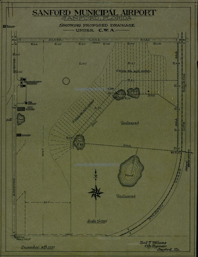
SANFORD MUNICIPAL AIRPORT
SANFORD, FLORIDA
SHOWING PROPOSED DRAINAGE
-----------UNDER C.W.A.----------
Beacon
SILVER LAKE ROAD
SANFORD AVENUE
Drain the 40 ft. centers
ATLANTIC COAST LIKE RAILROAD
ADMINISTRATION BUILDING
Pond
Pond
Drain the 40 ft. centers
Uncleared
GAS STATION
CITY HANGER
Ditch Pond
HANGER
Pond
Ditch
Natural
Water course[?
S.W. Cor.
December 4th 1933
Fred T. Williams
City Engineer
Sanford, Fla.
Still Image Item Type Metadata
Original Format
1 drawing
Physical Dimensions
17.25 x 13.25 inch
Collection
Citation
“Sanford Municipal Airport, Sanford, Florida: Showing Proposed Drainage,” RICHES, accessed July 28, 2026, https://richesmi.cah.ucf.edu/omeka/items/show/2519.