Map of the Ossie Quarters
Dublin Core
Title
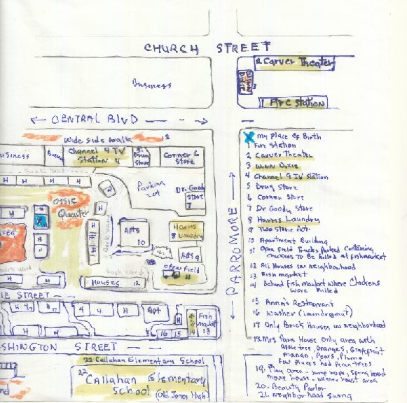
Map of the Ossie Quarters
Alternative Title
Ossie Quarters Map
Subject
Orlando (Fla.)
Description
A map of the Ossie Quarters, an area in the Parramore neighborhood of Downtown Orlando, Florida. The map was drawn in 2016 by Althea Hill, based on her memory of historic businesses and homes located in the neighborhood from 1951 through 1970. Ossie Quarters is located just north of Ossie Street, named in honor of Ossie Davis (1917-2005), a stage actor and civil rights activist.
Creator
Hill, Althea
Source
Original 8.5 x 11 inch hand-drawn color map by Althea Hill: Private Collection of Althea Hill.
Date Created
2016
Contributor
Hill, Althea
Is Format Of
Digital reproduction of original 8.5 x 11 inch hand-drawn map.
Is Part Of
Parramore Collection, Orlando Collection, Orange County Collection, RICHES of Central Florida.
Requires
Format
application/pdf
Medium
8.5 x 11 inch hand-drawn color map
Language
eng
Type
Still Image
Coverage
Ossie Quarters, Holden-Parramore, Downtown Orlando, Florida
Accrual Method
Donation
Mediator
History Teacher
Geography Teacher
Provenance
Originally created by Althea Hill.
Rights Holder
Copyright to this resource is held by Althea Hill and is provided here by RICHES of Central Florida for educational purposes only.
Contributing Project
Parramore History Harvest
Curator
Raffel, Sara
Digital Collection
Source Repository
Private Collection of Althea Hill
External Reference
Rajtar, Steve. A Guide to Historic Orlando. Charleston, SC: History Press, 2006.
Collection
Citation
Hill, Althea, “Map of the Ossie Quarters,” RICHES, accessed July 14, 2026, https://richesmi.cah.ucf.edu/omeka/items/show/7773.