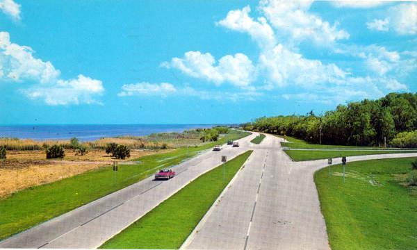
Approaching Sanford Along Lake Monroe
Dublin Core
Title
Approaching Sanford Along Lake Monroe
Alternative Title
Seminole Boulevard in Sanford
Subject
Waterfront Districts
Lakes & ponds
Lake Monroe (Seminole County and Volusia County, Fla.)
Transportation--Florida--History
Postcards--Florida
Highways
St. Johns River (Fla.)
Sanford (Fla.)
Description
Seminole Boulevard on the west edge of Sanford along Lake Monroe. Seminole Boulevard is the part of U.S. Highway 17 that runs along the coast of Lake Monroe in Sanford, Florida.
U.S. Highway 17 begins in Punta Gorda, briefly runs east, and then goes north along Peace River through Arcadia, Zolfo Springs, and Wauchula. The road then joins U.S. Highway 98 at Fort Meade and continues northward until Bartow, when it separates to travel northeast. At Winter Haven, U.S. 17 becomes concurrent with U.S. Highway 92 through Kissimmee, where both highways join U.S. Highway 192. When all three roads meet U.S. Highway 441, U.S. 17/92 turns north into downtown Orlando and then splits from U.S. 441 at State Road 50/Colonial Drove and continues east until it turns north at State Road 15/Mills Avenue.
In Sanford, U.S. 17/92 crosses over the St. Johns River into Volusia County and then splits north of DeLand as U.S. 17 travels north toward Palatka, again crossing the St. Johns River. The highway then continues through Clay County, suburban Jacksonville, and Nassau County until it reaches the Florida border. The entire highway spans across Florida, Georgia, South Carolina, North Carolina, and Virginia.
Lake Monroe is a lake that is part of the St. Johns River system in Florida and is also the eigth largest lake in the Orlando metropolitan area. Sanford is located on its northern shore and DeBary and Deltona are located along its northern shore. Two major roadways, State Road 415 and Interstate 4, run near the lake. Lake Monroe also formes the border of Seminole County and Volusia County.
Creator
Orange News Company
Source
Original 4 x 6 inch color postcard by Orange News Company: Postcard Collection, call number PC5643, Florida Photographic Collection, State Library and Archives of Florida, Tallahassee, Florida.
Publisher
Date Created
ca. 1960-1990
Is Format Of
Digital reproduction of original 4 x 6 inch color postcard by Orange News Company on Florida Memory Project: Postcard Collection, call number PC5643, Florida Photographic Collection, State Library and Archives of Florida. http://floridamemory.com/items/show/163495.
Is Part Of
Postcard Collection, Florida Photographic Collection, State Library and Archives of Florida, Tallahassee, Florida.
Sanford Riverfront Collection, Sanford Collection, Seminole County Collection, RICHES of Central Florida.
Format
image/jpeg
Extent
35 KB
Medium
4 x 6 inch color postcard
Language
eng
Type
Still Image
Coverage
Sanford, Florida
Spatial Coverage
28.83239, -81.320854
Temporal Coverage
1960-01-01/1990-12-31
Accrual Method
Deposit
Audience Education Level
SS.K.A.1.2; SS.1.A.1.1; SS.2.A.1.1; SS.3.A.1.1; SS.3.A.1.2; SS.4.A.1.1; SS.4.G.1.1; SS.5.A.1.1; SS.6.W.1.3; SS.8.A.1.2; SS.8.A.1.5; SS.912.A.1.2; SS.912.A.1.4 SS.912.W.1.3
Mediator
History Teacher
Geography Teacher
Provenance
Originally created and owned by Orange News Company.
Rights Holder
Copyright to this resource is held by the State Library and Archives of Florida, and is provided here by RICHES of Central Florida for educational purposes only.
Curator
Cepero, Laura
Source Repository
External Reference
Sanford Historical Society (Fla.). Sanford. Charleston, SC: Arcadia, 2003.
"Monroe Harbour Marina." Monroe Harbour Marina. http://www.monroeharbour.com/.
External Reference Title
Sanford Historical Society, Inc. Images of America: Sanford. Charleston, South Carolina: Arcadia Publishing, 2003.
Still Image Item Type Metadata
Original Format
1 color postcard
Physical Dimensions
4 x 6 inch
Collection
Citation
Orange News Company, “Approaching Sanford Along Lake Monroe,” RICHES, accessed February 15, 2026, https://richesmi.cah.ucf.edu/omeka/items/show/452.
