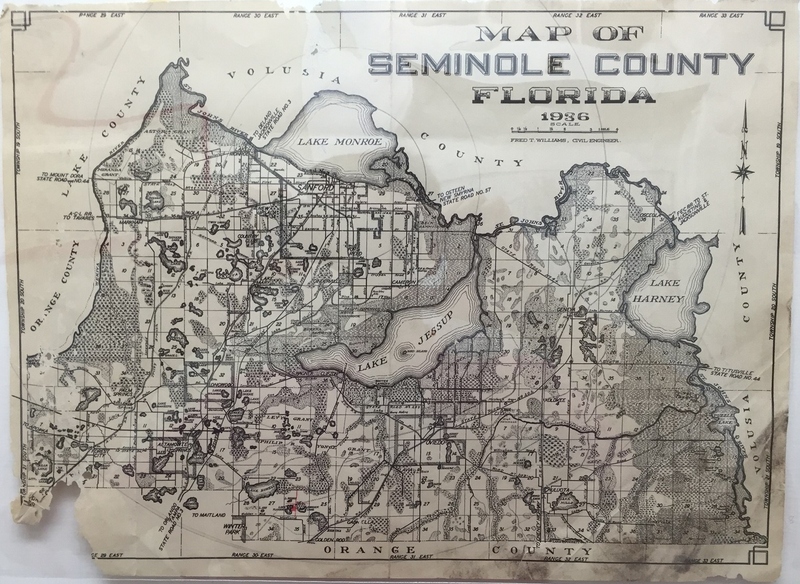
Map of Seminole County, Florida, 1936
Dublin Core
Title
Map of Seminole County, Florida, 1936
Alternative Title
Map of Seminole County
Subject
Seminole County (Fla.)
Description
Created in 1936 by Sanford’s city engineer, Fred T. Williams, this surveyor's map depicts Seminole County, Florida. During his tenure as city engineer from the 1920s through the early 1940s, Williams created multiple maps that show how Sanford has changed as the city limits grew and the city become more populated. Unlike some of the previous maps created by Williams, there seems to be no legend detailing the map.
Seminole County separated from Orange County on April 25, 1913, and was named for the Seminole tribes that originally inhabited the area. In the early-1900s, Seminole County was known for its agricultural development and close proximity to shipping lanes. By the 1920s, citizens in Seminole County, particularly in Sanford, soon shifted their interests in making the area a tourist destination.
Seminole County separated from Orange County on April 25, 1913, and was named for the Seminole tribes that originally inhabited the area. In the early-1900s, Seminole County was known for its agricultural development and close proximity to shipping lanes. By the 1920s, citizens in Seminole County, particularly in Sanford, soon shifted their interests in making the area a tourist destination.
Creator
Williams, Fred T.
Source
Original 12 x 9 inch black and white map by Fred T. Williams, 1936: Museum of Seminole County History, Sanford, Florida.
Date Created
1936
Is Format Of
Digital reproduction of original 12 x 9 inch black and white map by Fred T. Williams, 1936.
Is Part Of
Museum of Seminole County History, Sanford, Florida.
Seminole County Collection, RICHES of Central Florida.
Format
image/jpg
Extent
1.08 MB
Medium
12 x 9 inch black and white map
Language
eng
Type
Still Image
Coverage
Sanford, Florida
New Upsala, Florida
Lake Mary, Florida
Ginderville, Florida
Cameron City, Florida
Fort Reed, Florida
Osceola, Florida
Geneva, Florida
Forest City, Florida
Altamonte Springs, Florida
Longwood, Florida
Gabriella, Florida
Goldenrod, Florida
Oviedo, Florida
Chuluota, Florida
Kolokee, Florida
Markham, Florida
Paola, Florida
Iowa City, Florida
Wagner, Florida
Clifton, Florida
Lake Monroe, Florida
Slavia, Florida
Accrual Method
Donation
Mediator
History Teacher
Geography Teacher
Provenance
Originally created by Fred T. Williams.
Rights Holder
Copyright to this resource is held by the Museum of Seminole County History and is provided here by RICHES of Central Florida for educational purposes only.
Curator
Fried, Aaron
Cepero, Laura
Digital Collection
Source Repository
External Reference
Bentley, Altermese Smith. Seminole County. Charleston, SC: Arcadia, 2000.
"Seminole County Government ." Seminole County Government. http://www.seminolecountyfl.gov/index.aspx.
Early Days of Seminole County, Florida: Where Central Florida History Began. [Sanford, Fla.]: Seminole County Historical Commission, 2002.
Still Image Item Type Metadata
Original Format
1 black and white map
Physical Dimensions
12 x 9 inches
Collection
Citation
Williams, Fred T., “Map of Seminole County, Florida, 1936,” RICHES, accessed February 22, 2026, https://richesmi.cah.ucf.edu/omeka/items/show/6429.
