Browse Items (2 total)
Sort by:
Map of Seminole County, Florida, 1936
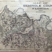
Created in 1936 by Sanford’s city engineer, Fred T. Williams, this surveyor's map depicts Seminole County, Florida. During his tenure as city engineer from the 1920s through the early 1940s, Williams created multiple maps that show how Sanford has…
Old Fort Reid Building
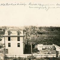
Former building at First Street and Magnolia Avenue prior to the construction of the N.P. Yowell and Garner Woodruff Buildings. The building was named after Fort Reid, which was established by Colonel William Harney on July 7, 1840. Colonel Harney…