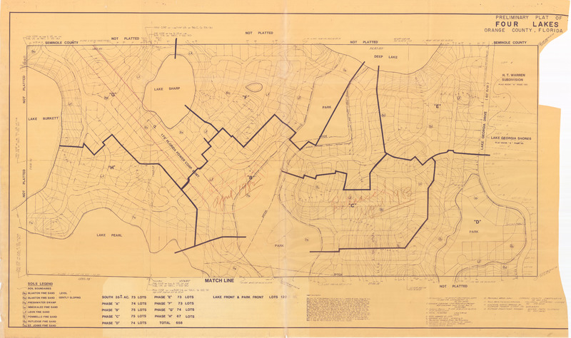
Preliminary Plat of Four Lakes, 1983
Dublin Core
Title
Preliminary Plat of Four Lakes, 1983
Alternative Title
Four Lakes Plat
Subject
Orlando (Fla.)
Description
A plat map showing the area around the Four Lakes area, located east of Florida State Road 436 near the border of Seminole County and Orange County, Florida. The area is named in reference to the four surrounding lakes: Lake Sharp to the north, Deep Lake to the northeast, Lake Pearl to the south, and Lake Burkett to the west. This plat map was prepared by Dyer, Riddle, Mills and Precourt, an Orlando-based engineering firm, in 1983.
Source
Original 61 x 36 inch preliminary plat, April 1983: Pine Castle Historical Society, Pine Castle, Florida.
Publisher
Date Created
1983-04
Contributor
Lake, Harriett
Is Format Of
Digital reproduction of original 61 x 36 inch preliminary plat, April 1983.
Is Part Of
Orlando Collection, Orange County Collection, RICHES of Central Florida.
Format
image/jpg
Extent
2.68 MB
Medium
61 x 36 inch preliminary plat
Language
eng
Type
Still Image
Coverage
Four Lakes, Orlando, Florida
Accrual Method
Donation
Mediator
History Teacher
Provenance
Originally published by Dyer, Riddle, Mills and Precourt.
Rights Holder
Copyright to this resource is held by DRMP, Inc. and is provided here by RICHES of Central Florida for educational purposes only.
Curator
Barnes, Mark
Digital Collection
Source Repository
External Reference
"OUR HISTORY." DRMP. http://www.drmp.com/Our_History.html.
Collection
Citation
“Preliminary Plat of Four Lakes, 1983,” RICHES, accessed February 12, 2026, https://richesmi.cah.ucf.edu/omeka/items/show/7471.
