Map of Zellwood Drainage and Water Control District Unit No. 1 and Unit No. 2
Dublin Core
Title
Map of Zellwood Drainage and Water Control District Unit No. 1 and Unit No. 2
Alternative Title
Zellwood Drainage and Water Control District Map
Subject
Agriculture--Florida
Water quality--Florida
Lake Apopka (Fla.)
Description
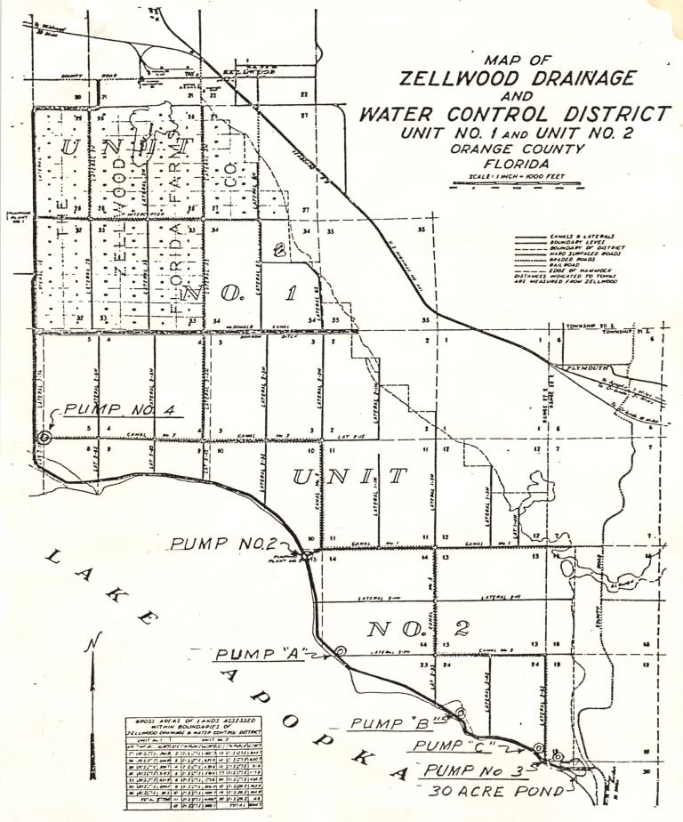
A map that identifies pump stations, canals, and allotments within Unit No. 1 and Unit No. 2 of the Zellwood Drainage and Water Control District (ZDWCD), which was created by the Florida Legislature in 1941 for taxation and land management of farming areas on the north shore of Lake Apopka. The district was granted powers of self-taxation and permitted to construct canals, bridges, and dikes in the area. The north shore farms were constructed on "muck land" created by the drainage of wetlands bordering Lake Apopka. The soil in these areas, often called "muck soil," is highly fertile and vulnerable to oxidation. The ZDWCD was permitted to routinely flood farmlands, when not in use, in order to keep the soil wet and preventing its loss to oxidation. These lands would then be drained before each growing season and this water was discharged back into Lake Apopka. Practices like these were considered to contribute to the pollution of Lake Apopka, with the discharge of fertilizer-rich water creating conditions of “eutrophication” in the lake and promoting the growth of harmful algae.
The Friends of Lake Apopka (FOLA), a citizen advocacy group organized for the environmental restoration of Lake Apopka in the early 1990s, lobbied for increased restrictions on the district’s ability to utilize water from Lake Apopka. These efforts culminated in a buyout of the Zellwood Drainage and Water Control District farmlands by the State of Florida in 1998, and farming operations ceased in June of that year. The ZDWCD was dissolved by the Florida Legislature in September of 2000.
The Friends of Lake Apopka (FOLA), a citizen advocacy group organized for the environmental restoration of Lake Apopka in the early 1990s, lobbied for increased restrictions on the district’s ability to utilize water from Lake Apopka. These efforts culminated in a buyout of the Zellwood Drainage and Water Control District farmlands by the State of Florida in 1998, and farming operations ceased in June of that year. The ZDWCD was dissolved by the Florida Legislature in September of 2000.
Source
Photocopy of original map, 1979: binder 1979, Friends of Lake Apopka Archives, Ginn Museum, Oakland Nature Preserve, Oakland, Florida.
Date Created
ca. 1979
Is Format Of
Digital reproduction of photocopied map, 1979.
Is Part Of
Binder 1979, Friends of Lake Apopka Archives, Ginn Museum, Oakland Nature Preserve, Oakland, Florida.
Friends of Lake Apopka Collection, RICHES of Central Florida.
Format
image/jpg
Extent
185 KB
Medium
1-page map
Language
eng
Type
Text
Coverage
Lake Apopka, Florida
Accrual Method
Donation
Mediator
History Teacher
Geography Teacher
Rights Holder
Copyright to this resource is held by the Friends of Lake Apopka and is provided here by RICHES of Central Florida for educational purposes only.
Contributing Project
Curator
King, Joshua
Digital Collection
Source Repository
External Reference
Jackson, Jerry. "Reaping Bucks From Muck Central Florida's $70 Million Vegetable Industry Thrives In Rich Soil." The Orlando Sentinel, August 12, 1985. Accessed August 1, 2015. http://articles.orlandosentinel.com/1985-08-12/business/0320160151_1_vegetable-industry-muck-lake-apopka.
"Special District Accountability Program." Florida Department of Economic Opportunity. Accessed August 1, 2016. https://dca.deo.myflorida.com/fhcd/sdip/OfficialListdeo/dissolved.cfm.
Collection
Citation
“Map of Zellwood Drainage and Water Control District Unit No. 1 and Unit No. 2,” RICHES, accessed July 25, 2026, https://richesmi.cah.ucf.edu/omeka/items/show/7963.