Browse Items (6 total)
Sort by:
Map of Daytona and Surroundings, 1896
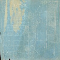
An 1896 map of Daytona and its surroundings in Volusia County, Florida, prepared by D. D. Rogers. The map covers the area from the Atlantic Ocean west to Fifth Street and from Mason Street south to Fremont Avenue. It shows three bridges across the…
Map of Daytona and Vicinity, Volusia County, Florida
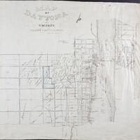
An undated map of Daytona and vicinity in Volusia County, Florida, prepared by D. D. Rogers. It depicts the Atlantic Ocean and Halifax River and identifies Pinewood Cemetery, a wagon bridge connecting Fairview and Seabreeze avenues, the Halifax Post…
Plat of Property Belonging to Jno. Anderson Situated at Ormond, Florida, 1904
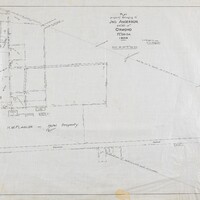
A 1904 plat of property belonging to John Anderson in Ormond, Florida, prepared by D. D. Rogers. The map shows the Halifax River shoreline, the U.S. Survey meander line, an arbor walk, drives and structures, Fire Trail Road, orange groves, a packing…
Report of Proposed System of Waterworks for the City of Daytona, Florida
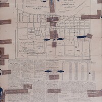
An April 1908 report and map outlining a proposed waterworks system for the City of Daytona, Florida. The mapped distribution system covers the area from Beach Street to Fourth Street and from Fremont Avenue to Arlington Avenue and identifies the…
Plot of D. D. Rogers Frontage on the Halifax River
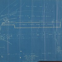
A detailed plot of D. D. Rogers's frontage on the Halifax River extending to Lot 5, Block 2 of Coleman's Addition to Daytona, Florida. The map documents Fairview Avenue, the Beach Street fill, the old shell bank, Coleman Road, Orange or Manley…
The Official Map of Holly Hill
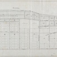
The official map of Holly Hill, Volusia County, Florida, compiled by D. D. Rogers and C. M. Rogers in May 1905. The map depicts the area from the Halifax River to Center Street and includes the Mason and Carswell Subdivision, Mason Avenue, North…