Map of Orange County, Florida, 1890
Dublin Core
Title
Map of Orange County, Florida, 1890
Alternative Title
Map of Orange County
Subject
Orange County (Fla.)--Maps
Seminole County (Fla.)--Maps
Cadastral maps
Description
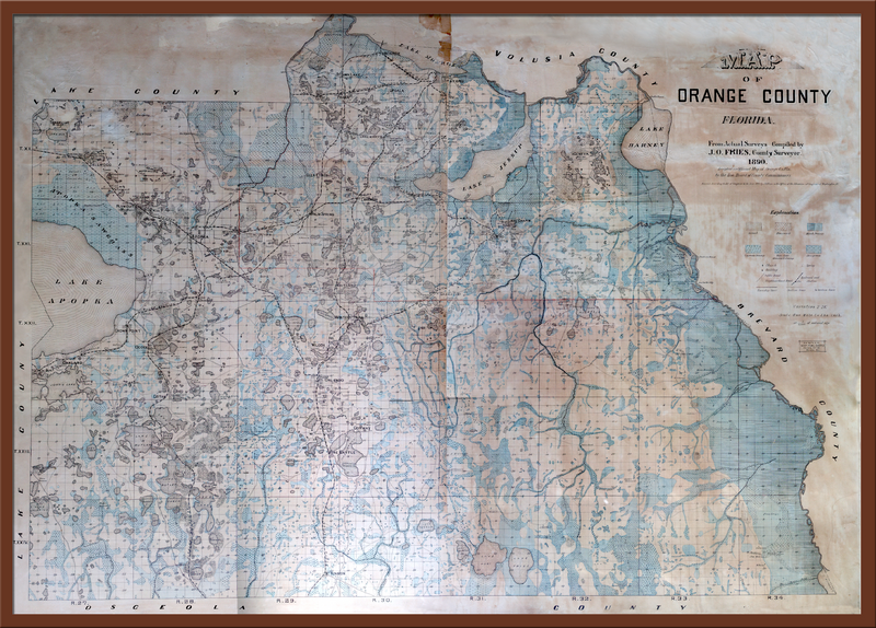
Surveyor and cadastral map of Orange County, Florida, which included present-day Seminole County. This map was created by a Swedish immigrant, J. Otto. Fries, in 1890. Coming to America in 1874, Fries was a respected civil engineer that later attended the University of Florida. He was hired by Orange County to create this surveyor’s map with all of its distinct features.
This map is very special because of two unique characteristics. Firstly, it is a topographical and a cadastral map, showing the physical features and real estate of the area. Secondly, this map includes local family names on the location of their residence, something that is quite rare for public maps. Also, this map shows Orange County before it was split into two different counties: Seminole County and Orange County. This map was kept in the Seminole County Courthouse in Sanford until 1913. In 1954, the map was given as a gift from Jack Fox to Arthur Beckwith. From there, it was donated to the Museum of Seminole County History by Arthur Beckwith, where it has undergone extensive restoration to fix the discoloration, peeling edges, and ripped pieces.
This map is very special because of two unique characteristics. Firstly, it is a topographical and a cadastral map, showing the physical features and real estate of the area. Secondly, this map includes local family names on the location of their residence, something that is quite rare for public maps. Also, this map shows Orange County before it was split into two different counties: Seminole County and Orange County. This map was kept in the Seminole County Courthouse in Sanford until 1913. In 1954, the map was given as a gift from Jack Fox to Arthur Beckwith. From there, it was donated to the Museum of Seminole County History by Arthur Beckwith, where it has undergone extensive restoration to fix the discoloration, peeling edges, and ripped pieces.
Creator
Fries, J. Otto
Source
Original 56.75 x 42.5 inch color map by J. Otto Fries, 1890: E. W. Smith & Company: Philadelphia, 1890: Museum of Seminole County History, Sanford, Florida.
Publisher
E. W. Smith & Company
Date Created
1890
Date Copyrighted
1890
Is Format Of
Digital reproduction of 56.75 x 42.5 inch color map by J. Otto Fries, 1890: E. W. Smith & Company: Philadelphia, 1890.
Is Part Of
Museum of Seminole County History, Sanford, Florida.
Orange County Collection, RICHES of Central Florida.
Format
application/pdf
Extent
52.8 MB
Medium
56.75 x 42.5 inch color map
Language
eng
Type
Still Image
Coverage
Orange County, Florida
Seminole County, Florida
Accrual Method
Donation
Mediator
History Teacher
Geography Teacher
Provenance
Originally created by J. Otto Fries and published by the E.W. Smith & Company.
Rights Holder
Copyright to this resource is held by the Museum of Seminole County History and is provided here by RICHES of Central Florida for educational purposes only.
Contributing Project
Curator
Cepero, Laura
Digital Collection
Source Repository
External Reference
"Orange County Government." Orange County Government. http://www.ocfl.net/.
"Seminole County Government." Seminole County Government. http://www.seminolecountyfl.gov/index.aspx.
"Museum of Seminole County History." Seminole County Government. http://www.seminolecountyfl.gov/departments-services/leisure-services/parks-recreation/museum-of-seminole-county-history/.
Blackman, William Fremont. History of Orange County, Florida; Narrative and Biographical. Chuluota, Fla: Mickler House, 1973.
Howard, Clarence E. Early Settlers of Orange County, Florida: Reminiscent-Historic-Biographic. Orlando, Fla: C.E. Howard, 1915.
Early Days of Seminole County, Florida: Where Central Florida History Began. [Sanford, Fla.]: Seminole County Historical Commission, 2002.
Still Image Item Type Metadata
Original Format
1 color map
Physical Dimensions
56.75 x 42.5 inch
Collection
Citation
Kim Nelson, “Map of Orange County, Florida, 1890,” RICHES, accessed July 15, 2026, https://richesmi.cah.ucf.edu/omeka/items/show/1671.