Browse Items (4 total)
Sort by:
Oviedo Area Map and Business Guide
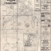
An area map of Oviedo, Florida, and its surrounding areas. A number of advertisements from the businesses surrond the perimeter of the map. While the date is unknown, the map is believed to have been published sometime between 1970 and 1978. The…
South Florida Argus Vol 2., No. 15, January 6, 1886
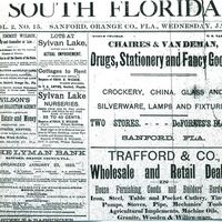
The South Florida Argus Vol. 2, No. 15 issue for January 6, 1886. This issue included advertisements for several Sanford-based businesses, including Wilson's Collection Agency, Charles & Vandeman's drug store, the Lyman Bank, and Trafford and…
The South Florida Argus Advertisements (January 3, 1886)
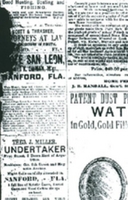
A page of newspaper advertisements in The South Florida Argus issue for January 3, 1886. This issue includes advertisements for various Sanford-based businesses, including the Home Fertilizer Company, Chase and Company, and the Wigwam.The South…
Map of Orange County, Florida, 1890
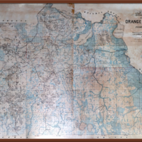
Surveyor and cadastral map of Orange County, Florida, which included present-day Seminole County. This map was created by a Swedish immigrant, J. Otto. Fries, in 1890. Coming to America in 1874, Fries was a respected civil engineer that later…