Browse Items (6 total)
- Tags: Pine Castle
Grid Map of Unincorporated Communities South of Orlando
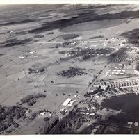
Sky Lake, 1958
California Classics: Homes by Wm Lyon: Huntington Series
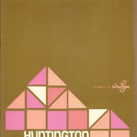
Tags: architecture; California Classic; California Classics; Cerritos, California; Concord, California; Conejo Valley, California; Dutch Haven Marina; Fairmont Place; Fountain Valley, California; Franciscan Fountains; Fullerton, California; home design; Homes with a Flair; housing; Huntington Beach; Huntington Beach, California; Huntington Series; model homes; Newport West; Oakcrest Series; Olive Lane; Pine Castle; Sacramento, California; San Jose, California; Shadow Downs; Sky Lake; Sunny Hills West; Terrace Kitchens; The Adams; The Bermudas; The Carolina; The Dearborn; The Dunsmuirs; The El Pasos; The Gainsboroughs; The Gates of Sunny Hills; The Greenwich; The Lexingtons; The Oaks; The Santa Fes; The Santa Rosas; The Scottsdale; The Tennysons; The Tucson; The Winslows; The Woodfords; Thousand Oaks, California; Walnut Woods; Wildwood; William Lyon; William Lyon Statewide Communities
Map of Orange County, Florida, 1890
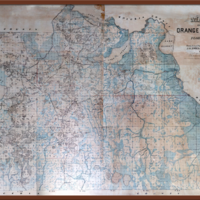
Tags: Apopka; Apopka Sawgrass; Big Sand Lake; cadastral map; Chuluota; Conway; E. W. Smith & Company; Fries, J. Otto; Gabriella; Glen Ethel; Gotha; Lake Apopka; Lake Charm; Lake Harney; Lake Jessup; Lake Monroe; Longwood; Maitland; map; McKinnon; Monroe; orange county; orlando; Oviedo; Palm Spring; Paola; Pine Castle; Plymouth; Sanford; Seminole County; surveyor map; Sylvan Lake; Upsala; Wilcox; Winter Park; Zellwood
Early Settlers of Orange County, Florida: Reminiscent-Historic-Biographic
Tags: 149th Pennsylvania Volunteer Company D; 1st Regiment Florida Volunteer Infantry; 2nd Regiment; A. A. Stone and Son; Abrams & Bryan; Addison, Illinois; Alabama; Alachua; Alden; Alexander, Elise; Allen, Edbert; Altamonte; Altamonte Springs; Altamonte Springs Hotel; Amarillo, Texas; American Antiquarian; American Revoluation; Anderson County, South Carolina; Angier, Edna I.; Ansonia, Connecticut; Apopka; Apopka Bank; Apopka Board of Trade; Apopka City; Apopka Drainage Company; Arkansas; Article 19; Astor; Astor Hotel; Athens, Georgia; Atlanta, Georgia; Atlantic City, New Jersey; Atlantic Coast Line Railroad Company; Augusta, Georgia; Back to the Soil; Baltimore College; Bank of Oakland; Barber, Andrew J.; Barber, Joseph A.; Barber, Maggie S. Simmons; Battle Creek, Michigan; Battle of Gettysburg; Battle of Shiloh; Battle of Vicksburg; Beck, Nannie Woodruff; Bedford County, Virginia; Beecher, Thomas K.; Beeman, H. L.; Benevolent and Protective Order of Elks; Berry, Jeane V.; Berry, Thomas W.; Berry, W. T.; Bingham School; Bird, Mary A.; Blakely, William P.; Blanchard, Charles; Blitz, J. M.; Board of Trade; Bogy Creek; Boone, C. A.; Boone's Early Orange; Boston, Massachusetts; Bradshaw; Bradshaw, Elise Alexander; Bradshaw, John Neill; Branche's Book Store; Brockton, Massachusetts; Brunswick, Georgia; Buck Horn Academy; Buck Tails; Buffalo, New York; Bullock; Burlington, Indiana; Burritt College; C. A. Boone and Company; Caldwell, C. V.; Calhoun County, Michigan; California; Cameron, Texas; Camp Monroe; Carnell, Willie; Carothers, Alice Bennett; Carson and Newman College; Carter; Center Township, Pennsylvania; Central Avenue; Chalmette, Louisiana; Chapman; Chapman, E. G.; Chapman, Foster; Chapman, John C.; Chapman, John T.; Chapman, Mattie P.; Chapman, R. Ethelyn; Chapman, Thomas A.; Chapman, William A.; Charleston Block; Chase Grove; Chasel Graves, James W.; Cheney & Odlin; Cheney, J. M.; Chicago, Illinois; China Grove; Church Street; Cincinnati Commercial; Citizens' National Bank of Orlando; citrus; Civil War; Clark County, Indiana; Clay Spring; Clay springs; Clerwater, Minnesota; Clouser, C. A.; Clouser, J. B.; Coacoochee; Cobb County, Georgia; Cockney; Coffee, John; Collins, Ailsey; Colorado; Columbia County; Columbia, Mississippi; Comanche, Oklahoma; Commandery; Como, Tennessee; Cones, Elliot; Confederacy; Confederate Army; Congress; Constitution; Conway; Conyers Academy; Conyers, Georgia; Cook's Ferry; Council Oak; County Antrim; county commissioner; Covington, Georgia; Cracker culture; Crawford, George W.; Crawfordville, Georgia; Creek Indians; Creeks; Crisey & Norris; Crown Point; Crown Point, Indiana; Cuba; Curtis & O'Neal; Curtis, Fletcher & O'Neal; Dade County; Dann Real Estate Agency; Dann, R. Edgar; Danville, Pennsylvania; Davidson College; Davis, E. H.; Davis, Frank H.; Davis, Mary; Demans, P. A.; Devlin, Minnie Elizabeth; Dickenson, Cynthia Ann Roberta; Dillard, J. L.; District School Trustees; Dixie; Dolive, W. L.; Dollins, Alice J. Rushing; Dollins, Alice Strickland; Dollins, Carl W.; Dollins, Hugh; Dollins, Hugh D.; Dollins, Kellie Rushing; Dollins, L. J.; Dollins, Mary; Dollins, Thomas A.; Dr. Stark; Dreer's; Dubuque, Iowa; Duke, James K.; Duke, Mary Kerr; Dule West, South Carolina; DuPage County, Illinois; Eastman's Business College; Efurt, Thuringia, Germany; Elizabethtown, New Jersey; Elks Club; Elm Grove Academy; Elmire Female College; Emmett, Michigan; Empire Hotel; England; Erksine College; Eureka; Everglades; Ewing, Earl W.; Ewing, Willie Carnell; Fairfield; Farrel Iron Foundry; FEC; Fernandez, Hallie G.; Fernandez, Henry Gore; Fifth New Hampshire Regiment; Fifth Tennessee Infantry; First Baptist Church of Orlando; First National Bank of Cameron; First Presbyterian Church of Orlando; Fleming; Flemming, Francis P.; Florida; Florida Association of Architects; Florida Board of Architecture; Florida Citrus Exchange; Florida Cracker; Florida Midland Railroad; Florida Railroad Commission; Florida State Legislature; Florida State Senate; Fogg, N. H.; Ford Estate; Forest; Forst house; Fort Christmas; Fort Gatlin; Fort Mellon; Fort Myers; Fort Reed; France; Francis, Margaret M.; Franklin County, Tennessee; freemason; freeze; Fruit Growers' Association; Fudge, James; Gadsen County; Gainesville; Gainesville, Alabama; Galia County, Ohio; Gallowy, Nannie; Gardner, Maine; Garrett, Hardy; General Florida Statutes; Georgia; Georgia University; Giles, Edna Adelima; Giles, James L.; Giles, Leroy B.; Gore, Mahlon; Gotha; Gotha, Germany; Grand Theatre; Grant, Ulysses S.; Graves, Anna L.; Graves, Arthur F; Graves, George T.; Graves, Helen Louise; Graves, I. W.; Graves, James W.; Graves, Minnie M.; Great Freeze; Greek architecture; Greeley; Greensboro, Alabama; Greenwood; Griffin, :Lawrence Jefferson; Griffin, Able; Griffin, Benjamin Luther; Griffin, Helen; Griffin, Henrietta E.; Griffin, Hilda; Griffin, John W.; Griffin, Rebekah Wilcox; Griffin, Samuel S.; Griffin, Stanley S.; Griffin, Willie L. Vick; Griffin, Yancey R.; Grundy County, Illinois; Guilford, Connecticut; Guinnett County, Georgia; Guyette County, Georgia; Gwinnett County, Georgia; Halifax County, North Caroline; Halstead, Murat; Hand, C. M.; Hand, Carey; Hand, Charlie M.; Hand, Elijah; Hand, Harry E.; Hand, Henry; Happersett, S. H.; Happersett, Stella Alcesta Rollins; Harlem, Illinois; Harrisburg High School; Harrison, Minnie Odella; Havana, Illinois; Heard National Bank of Jacksonville; Henck, E. W.; Herd County, Georgia; Hernando County; Hertford County, North Carolina; Hill, Ben; Hill, W. J.; Hillsboro, Tennessee; Hiwassee College; Hoffner, Charles H.; Hoffner, Edna I. Angier; Hoffner, Harry A.; Holshouser, Cynthia Ann Roberta Dickenson; Holshouser, Linnie Wilkins; Home Guards; Homestead; Honduras; Hoole, James L.; Hoosier Springs Grove; House of Representatives; Houston, Texas; Howard, Clarence E.; Howard's Grove, Wisconsin; Hudnal, Edward; Hudson; Hudson Battery; Hudson, Alfred B.; Hughey, J. P.; Hughey, John; Hull, Emily Harriett; Hull, William Benjamin; Hupple, Bernhart; Hupple, Friederika; Hyers, T. G.; Illinois; Indian architecture; Indian River; Indian River, Georgia; Ireland; Irmer, Lillian Maguire; Iron Bridge; Ironton, Ohio; Italy; J. B. Clouser and company; Jackson; Jackson, Helen Augusta; Jackson, Joseph; Jacksonvile; Jefferson City, Tennessee; Jerome, H.; Jerome, R. P.; John Hopkins Hospital; Johnson, Joseph, E.; Jones, John W.; Jones, W. S.; Journegan; Kendrick; Kentucky; Kerr, John P; Kerr, Margaret; Kerr, Mary; Kerr, Sarah Howard; Killingworth, Connecticut; Kilmer, Washington; Kincaid, M. C.; King Philip; King, Murray S.; Kirkwood; Kissimmee; Knights of Pythias; Knights Templar; Krez, Conrad; Kunz, George f.; Lake Apopka; Lake Butler; Lake Charity; Lake Conway; Lake Eola; Lake Faith; Lake Hope; Lake Howell; Lake Jessamine; Lake Monroe; Lake Osceola; Lakeland; Lakeview Cemetery; Laughlin, Frances; Lebanon, Ohio; Lee County, Texas; Lee University; Lee, A.; Lewis, Arthur A.; Lewis, Grace; Lewis, James M.; Lewis, Joseph M.; Lewter, Elva jouett; Lewter, Frederick Augustus; Lewter, Frederick Augustus, Jr.; Lewter, Irma; Lewter, Jewell; Lewter, John T.; Lewter, Laura Louise; Lewter, Linnie Wilkins Holshouser; Lewter, Mary Davis; Lewter, Medora Inex; Lewter, Robert Dickenson; Lewter, Roberta; Lewter, William Ferderick; Lewter, Zelma Kight; Lightwood Camp; Litchfield; Lockhart; Loganville, Georgia; London, England; Longwood; Longwood Hotel; Lord, Charles; Louisville, Kentucky; Loveless, Harry; Lovell House; Lucerne Circle; Lucerne Theatre; Lumsden, H. A.; Luther, E.; Luther, Martin; Lynch, William Brigham; MacDonald, Robert; Macon, Georgia; Madison, James; Magnolia Avenue; Magnolia Hotel; Magruder, C. B.; Magruder, James Bailey; Maguire, Charles Hugh; Maguire, David O.; Maguire, Fred H.; Maguire, J. O.; Maguire, Lillian; Maguire, Margaret M.Francis; Maguire, Rayner F.; Maguire, Thomas C; Maguire, Washington University; Main Street; Maine; Maitland; Manchester High School; Manchester, New Hampshire; Marion County; Marks; Martin, Matthew; Martin, William; Maryland; Mason; Masonic Lodge; Masons; Massey & Warlow; Massey & Willcox; Massey, Keating & Willcox; Massey, L. C.; Massey, Louis C.; Matchett, J. W.; Mathews, Monroe; McAdow, Marian A.; McKinley, William; Meadows; Mecca; Mellen, Charles; Mellonville; Mercer University; Methodist Episcopal Church, South; Metropolitan Museum of Arts; Miles, Elizabeth J.; Miller, A. C.; Mills; Minor, Tyrannus J.; Missionary Baptist Church; Mitchell; Mizell, Joshua; Monroe; Moore County, Tennessee; Moore's Business College; Mosquito County; Mount Olivet Cemetery; Murfreesboro, North Carolina; Murphy, North Carolina; Muscatine, Iowa; Muzzy Eva L.; Muzzy, Eden; Nashville, Tennessee; Nassaua; National Guard of Florida; Native Birds of Song and Beauty; Nehrling, Carl; Nehrling, Elizabeth Ruge; Nehrling, Henry; Neill, John L.; Neill, Sarah Clay; New Mexico; New Orleans, Louisiana; New Smyrna, Florida; New York; Newton, A. B.; Newton, Alice Bennett Carothers; Newton, Isaac; Newton, Minnie Odella Harrison; Niemeyer, F. J.; North Carolina; North Carolina University; Northampton County, North Carolina; O'Neal, William R.; Oak Lodge; Oak Ridge; Oakland; Ocoee; Odd Fellows; Odlin, L.; Ohio; Orange Avenue; Orange Belt Railroad; orange county; Orange County Board of Commissioners; Orange County Board of Public Instruction; Orange County Court; Orange County Criminal Court; Orange County Democratic Executive Committee; Orange County Fair Association; Orange County Pioneers' Association; Orange County School Board; Orange County, North Carolina; oranges; orlando; Orlando Bank and Trust Company; Orlando Board of Trade; Orlando Coast Line Railroad; Orlando Country Club; Orlando Driving Park Association; Orlando Electric Lighting; Orlando High School; Orlando Telephone Company; Orlando Water company; Osborn, L. C.; Osceola; Osceola County; Overstreet Crate Company; Overstreet Turpentine Company; Overstreet, Elizabeth; Overstreet, Hazel; Overstreet, Mildred; Overstreet, Moses M.; Overstreet, R. Ethelyn; Overstreet, Rachel E.; Overstreet, Robert T.; Palatka; Palm Beach; Palm Cottage; Palmer, Jerome; Palmer, W. L.; Palmer, Willis L.; Panola County, Mississippi; Paris, Tennessee; Parramore, Minnie M. Grave; Patrick, W. A.; Pennfeld, Michigan; Pennington Grove; Pennsylvania; People's Party; Peoples Bank of Sanford; Peoples National Bank of Orlando; Perry County, Pennsylvania; Pettus Artillery; Philadelphia, Pennsylvania; Pickens; Pigue; Pike County, Mississippi; Pine Castle; Pine Street; Plant City; Plymouth; Porter, Dwight D.; Pughkeepsie, New York; R. H. White Dry Goods Company; Randolph Peninsula; Rawlins, Anna L. Grave; Rawls, E. Judson; Reasoner Brothers; Richmond College; Richmond, Virginia; Roanoke, Virginia; Roberts, Alice J.; Robinson Avenue; Robinson Spring; Robinson, Samuel Austin; Rock Ledge, Georgia; Rollins College; Rollins, Florida Estelle; Rollins, Helen; Rollins, Helen Augusta Jackson; Rollins, John H.; Rollins, Stella Alcesta; Roman architecture; Roosevelt, Theodore; Roper; Roper, Alice; Royal and Select Master Masons of Florida; Royal Arch Masons; Rushing, Kellie; Russell County, Alabama; Rutland's Ferry; Sadler, Alice L.; Sadler, Anna E.; Sadler, John H.; Sadler, Minnie M. Tilden; Salem, Michigan; Saline County, Illinois; Sanford; Sanford High School; Saulsbury, North Carolina; Saunders-Massey, Elizabeth M.; Savannah, Georgia; Schohant, New York; Sea Island cotton; Seaboard Coast Air Line Railroad; Searcy, James; Searcy, John Neill; Searcy, Robert; Searcy, Sarah Clay Neill; Secession Convention; Secoffee; Second Seminole War; Seegar, S. J. T.; Seminole County; Seminole County Bank; Seminole County Sheriff; Seminole Hotel Company of Winter Park; Seminole Indians; Seminole Wars; Seminoles; Senate; Sentinel Printing; settlers; Shakespeare, William; Shannon, Mississippi; Sheboggan County, Wiscosin; Shelbyville, Indiana; Sherman; Shiloh; Shine, Elizabeth Agnes; Simmons, Maggie S.; Simpson, William; Sims Grove; Sims, B. M.; Sims, Eugene O.; Sims, J. Walter; Smith, Elizabeth J. Miles; Smith, Walter; Smith, William; South Apopka; South Apopka Supply Company; South Carolina; South Florida Fair Association; South Florida Foundry and Machine Company; South Florida Railroad; South Lake Apopka Citrus Growers' Association; Southern Express Company; Spanish Mission architecture; Spanish-American War; Sparkman; Speer; Speer, A.; Speer, Alice Roper; Speer, Gertrude K.; Speer, J. G.; Speer, James P.; Speer, Jason P.; Speer, Sidney; Speer, William; Spencer County, Tennessee; St. Augustine; St. Johns County; St. Johns River; State Bank of Orlando; Staunton, Virginia; Steinmetz, John B.; Stevens County, Oklahoma; Stewart, J. C.; Stone, A. A.; Stone, Alvord Alonzo; Stone, L. L.; Stone, Lovell Lazell; Strickland, Alice; Strong, Edward Malten; Sub-Tropical Mid-Winter Exposition; Summer Street; Summerlin Hotel; Summerlin House; Swedes; Sweeney, Robert; Switzerland; T. J. Minor and Brother; Taft, William H.; Talbot County, Georgia; Tallahassee; Tampa; Tampa & Gulf Railroad; Taylor Safe Manufacturing Company; Telfair County, Georgia; Tennessee; Texas; Thayer, Jessie M.; The Arcade; The Auk; The Citizen; The Jacksonville Times-Union; The Lodge; The Orange County citizen; The Orange County Reporter; The Orlando Reporter-Star; The Orlando Star; The Reporter-Star; The Seminole; The Sentinel; The Tampa Tribune; Thompson, Albert; Thompson, Dexter C.; Three Graces Lakes; Tiedkie; Tilden; Tilden, L. F.; Tilden, Minnie M.; Titusville; Toronto, Canada; Town Herman, Wisconsin; Trammell, Park; Tullahoma, Tennessee; Turner, Anna Belle; Tuscaloosa County, Alabama; Tyner, C. R.; Union; University Law School; University of Pennsylvania; Vanderbilt; Vermont; Vick, J. H.; Vick, Willie L.; Vicksburg; Virginia; Wakalla, South Carolina; Wallerfield Sarah A.; Walton, Edwin S.; Warlow, T. Picton; Warnell Lumber Company; Warnell Lumber company Millers; Washington Place; Washington, D. C.; Watkins Block; Watson; Weathersbee, Allen; Wekiva River; Wekiwa River; Wekiwa Springs; Welaka; West Virginia; White, W. G.; Whitner, J. N.; Wiggs, Annie B.; Wilcox County, Georgia; Wilcox, Mark; Wilcox, Rebekah; Winter Garden; Winter Garden Water and Light Company; Winter Park; Wisconsin Men of Progress; Witherington, Anna Belle Turner; Witherington, H. H.; Woodruff & Watson; Woodruff, Ailsey Collins; Woodruff, Elizabeth Agnes Shine; Woodruff, Emma; Woodruff, Frank; Woodruff, Frank L.; Woodruff, Minnie Elizabeth Devlin; Woodruff, Nannie Galloway; Woodruff, Seth; Woodruff, Seth W.; Woodruff, W. W. W.; Woodruff, William W.; World's Fair; Yowell-Duckworth Building; Yulee Railroad; Zellwood
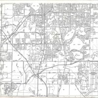
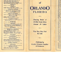
Street Map of Orlando
Tags: Albertson Apartments; Albertson Public Library; Alexander Apartments; Alexander Place; Allen Apartments; Allison, F. A.; Amelia Street; America Street; American League; American Legion; American Legion Building; Amherst Apartments; Anderson Street; Angebilt Church of the Nazarene; Angebilt Hotel; Ansonian Apartments; Associated Press; Atlanta Avenue; Atlantic Apartments; Atlantic Coast Line Railroad Company; Auten Apartments; Avalon Hotel; Babcock, H. C.; Bailey, M. D., Jr.; Batchelder, C. F.; Beacham Theatre; Big Tree Park; Bird Sanctuary; Bowling Club House; Bradshaw Apartments; Brass, George F.; Brethern in Christ Church; Broadway Apartments; Broadway Avenue; Broadway Methodist Church; Buena Vista Apartments; Butt-Bettes Investment Company; Calvary Presbyterian Church; Carl-Clayton Apartments; Carlyn Manor; Cary Apartments; Cathcart Avenue; Central Avenue; Central Christian Church; Cheney Court Apartments; Cheney Place; Cherokee Junior High School; Christian and Missionary Alliance; Church of God; Church of Jesus Christ of Latter Day Saints; Church of the Open Bible; Church Street; Claybaugh, Nat; College Park Baptist Church; Colonial Drive; Colonial Orange Court Hotel; Columbia Avenue; Columbia Broadcasting System; Colvin Apartments; Community Church of God; Concord Avenue; Concord Grammar School; Concord Park Methodist Church; Concord Park School; Condict, H. V.; Confederate Soldiers, Sailors, and Statesmen Memorial; Congregation Ohev Sholem Synagogue; Congregational church; Conway Road; Cook Avenue; Cook, Thomas; Court Street; Crotts Apartments; Daetwyler Azalea Gardens; Delaney Street; Delaney Street Baptist Church; Delaney Street School; Dickson Azaela Park; Dixie Avenue; Dixie Highway; Dodendorf Apartments; Dubsdread Country Club; Duke Hall; Dwellere; Eastern Air Lines; Edgewater Drive; Elks Club; Elvan Apartments; Empire Hotel; Eola Drive; Ernestine Street; Estes Apartments; Estes, V. W.; Exposition Park and Fair; Fern Creek Avenue; Fern Creekl Walker Memorial Methodist Church; First Baptist Church of Orlando; First Church of Christ, Scientist; First Federal Savings and Loan Association of Orlando; First Methodist Church of Orlando; First National Bank at Orlando; First Presbyterian Church of Orlando; First Unitarian Church of Orlando; Florence Apartments; Florida Motor Lines; Florida Public Service Company; Florida Sanitarium; Floyd-Lindorf Realty Company; Forst Gatlin Hotel; Fosgate Apartments; Frederick, Harlow G.; Frey Apartments; Gaston Edwards Park; Geeslin & Miller, Inc.; Gifford Arms; Gladstone Apartments; Goss Memorial Methodist Protestant Church; Grand Avenue Grammar School; Grand Theatre; Gray, M. Beck; Greater Orlando Chamber of Commerce; Guernsey, Frank D.; Guernsey, S. Kendrick; Hamlin Orange Grove; Hampton Avenue; Harlow G. Frederick, Inc.; Harold Shepherd Realty Company; Hartley Apartments; Harwood Avenue Apartments; Helen Street; Highland Avenue; Hillcrest Avenue; Hillcrest Grammar School; Holbrook, J. P.; Holyoke Apartments; Horse Shoe Club House; Hughey Street; Huttig, J. N.; Hyer & Davis; Hyer Avenue; Ivanhoe Apartments; Ivanhoe Boulevard; J. P. Holbrook Investment Company; Jackson Street; Jefferson Court Hotel; Jefferson Street; Jefferson Street Church of Christ; Jermone Realty Company; Jones, Elmer L.; Kaley Avenue; Kaley Avenue Grammar School; Kenhurst Apartments; Klock Apartments; Kuhl Avenue; Lake Adair; Lake Apopka; Lake Cherokee; Lake Concord; Lake Copeland; Lake Davis; Lake Eola; Lake Eola Bandshell; Lake Eola Fountain; Lake Estelle; Lake Formosa; Lake Ivanhoe; Lake Lancaster; Lake Lawson; Lake Lucerne; Lake Lurna; Lake o' the Woods Apartments; Lake Rowena; Lake Street; Lake Sue; Lake Underhill; Lake Virgina; Lakeview Street; Lamar Hotel; Lawn Bowling Club; Lawton Investment Companu; Leon Hotel; Liberty Avenue; Linwood Apartments; Livingston Apartments; Livingston avenue; Livingston Street; Llanymor Hotel; Long Apartments; Lucerne Hotel; Lucerne Park Baptist Church; Luker Apartments; Madison Apartments; Magil Apartments; Magnolia Avenue; Main Street; Mann Apartments; Manuel Courts Apartments; Mariposa Street; Marks Street; Marks Street Grammar School; Masonic Temple; McKelvey, Vernon; McNutt, Heasley & Bailey; Mead Botanical Gardens; Memorial Junior High School; Miller Memorial Baptist Church; Mills Avenue; Mills Street; Minnichaha Apartments; Minnie Paul Apartments; Montana Avenue; Moss, M. J., Jr.; Murchison Company; National Airlines; New Apartments; New England Avenue; New Greenhurst Apartments; New Keystone Apartments; New Poinsettia Apartments; Normant Apartments; North Park Baptist Church; O-Po-Le-O; O. P. Swope, Inc.; O'Neal Investment Company; Orange Avenue; Orange County Armory; Orange Farms Company; Orange Fountain; Orange General Hospital; Orange Hotel; Orlando Christian Church; Orlando Country Club; Orlando Municipal Airport; Orlando Municipal Auditorium; Orlando Recreation; Orlando Reeves Memorial; Orlando Senior High School; Orlando Tennis Club; Orlando Transit Company; Orlando Unity Center; Orlando Utilities Commission Plant; Orlando Visitors Card Club; Orlando Vocational School; Osceola Hotel; Overstreet Land Company; Packard, J. H.; Palmetto Street; Palms Apartments; Park Avenue; Park Lake; Park Lake Presbyterian Church; Park View Apartments; Parramore Avenue; Parsons Apartments; Pearl Hotel; Pentecostal Assembly of God; Phillips, Welborn; Pine Castle; Pine Street; Price, W. K.; Princeton Avenue; Princeton Avenue Grammar School; Raleigh Street; Reeves Memorial Methodist Church; Reformed Presbyterian Church; Rex-McGill Investment Company; Rialto Theatre; Richey, E. H.; Richmond Hall; Ridgewood Apartments; Ridgewood Avenue; Robinson Avenue; Rollins College; Roque Club House; Rosalind Avenue; Rosalind Club; Rose, Walter W.; Roxy Theatre; Ruth Street; Salvation Army Citadel; San Juan de Ulloa Hotel; San Juan Hotel; Sanland Springs Tropical Park; Schoolfield Apartments; Schwob Apartments; Seaboard Air Line; Seventh Day Adventist Church of Orlando; Shepherd, Harold; Shuffleboard Club House; Simpson-Staton Company; Slayton, E. F.; Sligh Boulevard; Smith, Henry D.; Smith, Wyan; Solarium; South Street; Southern Apartments; Spann Apartments; Spring Lake; St. James Apartments; St. James Roman Catholic Cathedral; St. Johns River; St. Luke's Cathedral; St. Regis Apartments; Stewart, J. C.; Stoner, E.; Summerlin Street; Summerline Hotel; Sunshine Park; Sweet Pea Wall; Swope, O. P.; Taylor Apartments; Thornton Lane; Tinker Field; Tinker, Joe; Tremont Hotel; Trenton Street; Trinity English Lutheran Church; United Press and International News Service; University Club; Vergowe Agency; Wall Street; Walter W. Rose Investment Company; Washington Avenue; Washington Senators; WDBO; Weber Avenue; Wekiwa River; Wekiwa Springs; Wells Home Apartments; West Central Grammar School; Westmoreland Drive; Wild Rose Apartments; Wilmot, Fred W.; Wilson Apartments; Wood Apartments; Wynholm Apartments; Wyoming Hotel; Yale Avenue