Street Map of Orlando
Dublin Core
Title
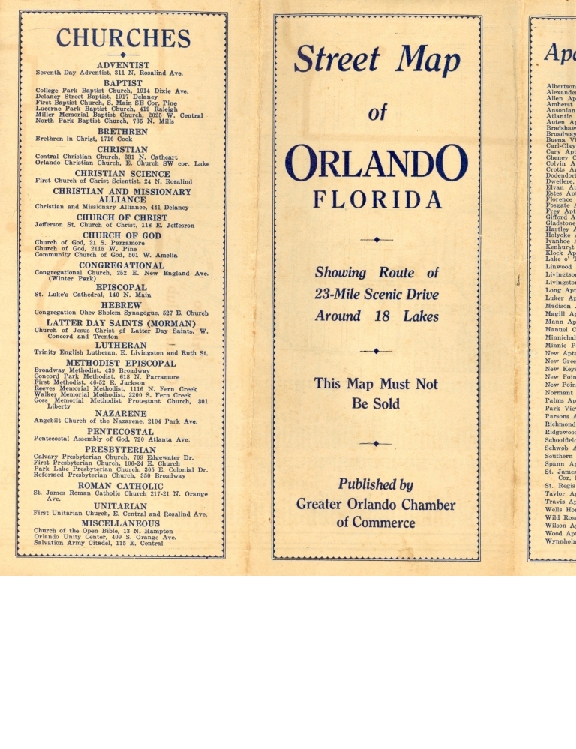
Street Map of Orlando
Alternative Title
Orlando Street Map
Subject
Orlando (Fla.)
Maps
Churches--Florida
Schools--Florida
Hotels--Florida
Description
Street map of the City of Orlando, Florida, printed in 1936. The map shows the route of a 23-mile scenic drive around 18 lakes in Orlando. It has listings of apartment houses, churches, hotels, real estate brokers, newspapers, schools, clubs, newspapers and more. The map also lists 66 places on the scenic drive illustrated on the map.
Source
Original 17 x 22 inch map, 1936: Greater Orlando Chamber of Commerce, Orlando, Florida: Private Collection of Thomas Cook.
Publisher
Date Created
1936
Date Copyrighted
1936
Contributor
Cook, Thomas
Is Format Of
Digital reproduction of original 17 x 22 inch map, 1936: Greater Orlando Chamber of Commerce, Orlando, Florida.
Requires
Format
application/pdf
Extent
4.87 MB
Medium
17 x 22 inch printed map
Language
eng
Type
Still Image
Coverage
Orlando, Florida
Winter Park, Florida
Spatial Coverage
28.533611, -81.375833
28.591865, -81.348492
Temporal Coverage
1936-01-01/1936-12-31
Accrual Method
Donation
Mediator
History Teacher
Economics Teacher
Geography Teacher
Provenance
Originally published by the Greater Orlando Chamber of Commerce.
Rights Holder
Copyright to this resource is held by the Greater Orlando Chamber of Commerce and is provided here by RICHES of Central Florida for educational purposes only.
Contributing Project
Curator
Cook, Thomas
Digital Collection
Source Repository
Private Collection of Thomas Cook
External Reference
Antequino, Stephanie Gaub, and Tana Mosier Porter. Lost Orlando. Charleston, S.C.: Arcadia Pub, 2012.
"Downtown Orlando Historic District Walking Tour." City of Orlando. http://sanfordhistory.tripod.com/Links/wtour.pdf.
Dickinson, Joy Wallace. A Guide to Historic Orlando. Charleston, SC: Arcadia Pub, 2003.
External Reference Title
Still Image Item Type Metadata
Original Format
1 printed map
Physical Dimensions
17 x 22 inch
Collection
Citation
“Street Map of Orlando,” RICHES, accessed July 16, 2026, https://richesmi.cah.ucf.edu/omeka/items/show/1022.