Browse Items (7 total)
Sort by:
Oral History of Dr. Stephen Caldwell Wright

Dr. Stephen Caldwell Wright was born and raised in Goldsboro, an historic African-American community in Sanford, Florida. He lived in Sanford for most of his early life, except for one year in Lakeland for ninth grade. He attended Goldsboro…
Zoning of U.S. Naval Air Station, Sanford, Florida
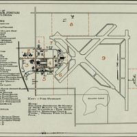
Drawing of the Naval Air Station in Sanford, Florida. This drawing shows a map of the zoning of the NAS Sanford. The air station was commissioned on November 3, 1942, as a naval aviation training facility during World War II. The Navy continued to…
Enlarged Photograph: Sanford, Florida
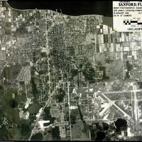
Aerial photograph of Sanford, Florida, taken on January 18, 1961. The photograph was taken by the U.S. Navy's Heavy Photographic Squadron 62 (VAP-62), with commanding officer John E. Cousins. This aerial view is at an altitude of 30,000 feet above…
Index Map: Station N.A.S. Sanford, Florida
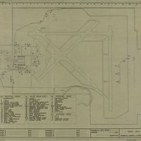
Index map of the Naval Air Station in Sanford, Florida. The air station was commissioned on November 3, 1942, as a naval aviation training facility during World War II. The Navy continued to train pilots at NAS Sanford throughout the Korean War and…
Naval Air Station Sanford Plat of Three Aviation Fields with Map of Seminole County

Plat of three aviation fields of the Naval Air Station (NAS) Sanford in Sanford, Florida, in 1941. A map of Seminole County, originally drawn in 1936, is also drawn on the back side. The air station was commissioned on November 3, 1942, as a naval…
New Tribes Mission International Headquarters, Sanford, Florida
History of the building for the New Tribes Mission International Headquarters, located at 1000 East First Street in Sanford, Florida. Originally named after the Sanford Mayor and president of Seminole County Bank, construction of the Forrest Lake…
Hanger at Naval Air Station Sanford
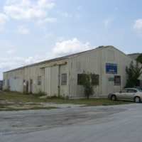
Original hanger from Naval Air Station Sanford. Became the Naval Air Station Sanford Restoration Facility. This building was the location for the restoration of the RA-5C Vigilante that became part of the Naval Air Station Sanford Memorial…